In continuation of our geocoding overview series, today’s post describes the scenario where a collision cannot be geocoded because the location does not exist in the available street network data. The location may not exist for several reasons:
- The street network is outdated so it does not contain new developments
- The street network is incorrect and the roads appear in a slightly different location
- The collision occurs at a driveway, alley or other private entrance that is not a public roadway
Typically the last situation is the most detrimental since those locations frequently have the highest number of collisions due to high traffic volumes. An example would be the private entrance to The Home Depot where a traffic signal exists at the intersection, but the entrance road is not included in the street network:
There were 25 collisions at this location over ten years, but none of them can be geocoded without manually editing our street network data.The original street network is shown as the red lines below. The Home Depot Pl entrance did not exist before, so we manually added a new feature shown by the blue line:
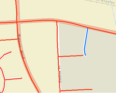
In addition to creating the new segment, we have to split the connecting Roscoe Blvd line feature at the vertex to ensure our geocoding process will recognize a valid intersection. At this point, the street network is ready to go, but the location will still not be recognized by the geocoder. We could rebuild the entire geocoder to add a new street, but it can be complicated and a lengthy process. Therefore, our solution is to manually set an XY coordinate for this location in a list of exceptions, just as we did for the offset intersections issue. All the collisions with primary road = Roscoe Blvd and secondary road = Home Depot Pl will be placed at the vertex. By doing that we can now properly offset any collisions that do not occur directly at the intersection. Many collisions occur on Roscoe Blvd east or west of Home Depot Pl and we have custom code to adjust for the offset from the nearest intersection.
In summary, after editing the street network our geocoding process is designed to read through a list of exception intersections and act accordingly. We try to identify the locations where there are the largest number of intersections with a similar name that are not geocoding and add them to the exception list. This is especially important if the location has one of the overall higher collision counts in the city and would otherwise be excluded. This does require an initial effort to locate trouble spots, but new sets of data will take advantage of this and geocode without any intervention.